

The Raintree trail is a popular 2.7-mile trek (each way) that takes hikers through scenic forests, past epic views and culminates in what many believe to be the oldest living thing in Nevada, a 3,000-year-old massive bristlecone tree.
Raintree Trail Hiking Stats
| Trail Description | Out and back |
| Location | Raintree, Forest Trail 041, Mt. Charleston, NV 89124 |
| Parking Lot | North Loop Trailhead |
| Round Trip Mileage | 5.4 miles |
| Average Time | 3.5 hours |
| Difficulty | Moderate The trail is considered moderate/hard. The trail is well marked and easy to follow with some tree roots and rocks to navigate along the way. There was no scrambling. What makes the trail moderate in our opinion is the elevation gain, distance and maximum elevation above sea level (nearly 10,000 feet). |
| Elevation Gain | ~1,650 feet Our Garmin said it was ~1,550 feet to the Raintree, plus about 100 or so feet coming back. Alltrails considers this a ~1,833 feet gain. |
| Elevation Start | ~8,396 feet (Source) |
| Elevation Max | ~9,996 feet |
| Best time to visit | Spring through Fall (the trail is accessible year-round, however heavy snow conditions may exist in the snow season). |
| Amenities at the Trailhead | Parking, boot brush station, trail map / information board. No restrooms available. |
| Entrance Fee | None |
| Rating | 5.0 Mooses |
What is the Raintree?
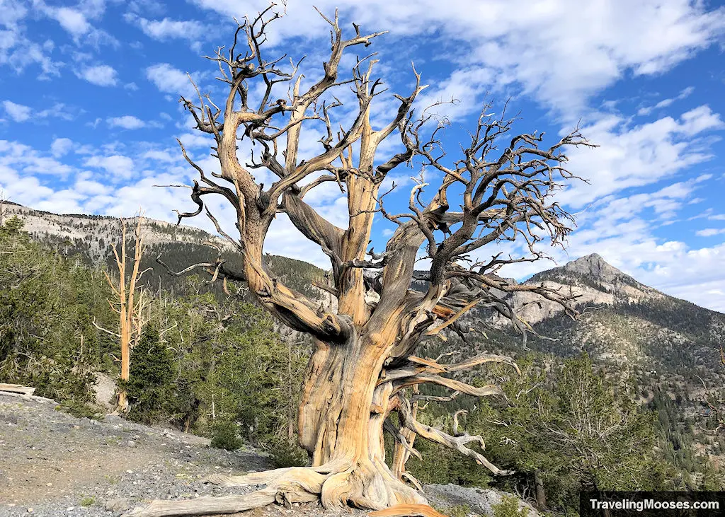
The Raintree is a large bristlecone pine tree that is estimated to be 3,000 years-old. Bristlecone pines are remarkable for being among the oldest living species on the planet.
You can identify a bristlecone tree by their uniquely twisted appearance, which is shaped from snow, wind and rain. They live in incredibly harsh climates, and tend to grow the oldest at higher elevations just below the tree line in mountainous areas. They will grow at lower elevations, but frequently fall victim to forest fires. These trees are rare, and can be found only in the states of California, Utah and Nevada.
They are also considered “non-clonal” which means the trunk of the tree is the same age as the root system. In contrast, there are many “clonal” trees, including “Pando” which is a colony of 48,000 aspen trees that is considered to be one of the oldest living organisms in the world. Clonal trees sprout “clones” from the original plant and share genetic markers. If you see a split bristlecone that is growing together (as is the Raintree), it is all the same tree and not a clone.

We weren’t able to find a source that definitely says the Raintree is 3,000-years-old, but there have been other similar bristlecones that were dated.
To date a tree, there are two options. Counting the rings of the trunk (which requires the tree to be cut down), or inserting a “borer” that extracts a small segment of the tree (leaving the tree intact).
In 1964, Donald R. Currey was granted permission from the U.S. Forest Service, to date a famous bristlecone called “Prometheus.” While accounts vary on whether a borer machine was used and deemed ineffective, ultimately Prometheus was cut down and the rings were counted. It was determined to be approximately 4,900 years old.
RIP Prometheus.

Given the size and stature of the Raintree as compared with other bristlecones, the 3,000-year-old estimate seems to be fitting.
You can read more about these famous bristlecone trees here.
What to expect along the Raintree trail
We arrived at 7:10 a.m. on a weekend and found the parking area was mostly full.
The good news is, there is an overflow parking area just down the street. Cars also parked on the narrow shoulder off NV-158 (we don’t recommend this). See more parking details here.
The Raintree trail starts at the North Loop Trailhead off of NV-158 (also known as Deer Creek Road). The out and back trail is approximately 5.4 miles round trip and you can add either Fletcher Peak or Mummy Springs if you’re looking for an additional challenge.

If you’re feeling really ambitious, the North Loop also leads to the summit of Mount Charleston (20.6 miles round-trip).
The Trail
The trail starts out gentle, and after a short incline, actually dips back down in elevation.

Don’t get too attached to the downward sloping trail. It’s short lived and soon you’ll be marching up to the top of Bristlecone Peak (approximately 9,996’ in elevation).
Note: Bristlecone Peak’s elevation is ~10,045′. The highest point I could find on the official trail to Raintree was ~9,996′.

In fact, the first half of the trail (~1.3 miles) is a steady dose of upward climbing through switchbacks and mostly shaded paths.
Keep your eyes posted for various birds along the trail.

During this portion of the trail, you’ll get to see several nice views of the valley facing east, and various mountain backdrops facing to the west.

Before coming to the approximate halfway mark to the Raintree, the bristlecone pines will begin making an appearance on the trail.
There’s a great stopping point by the tree shown in the picture above. You’ll know you’ve arrived there as it’s the first major clearing on top of a ridge with beautiful views of the Vegas valley to the east.

Not long after this vantage, you’ll come to a flat area. It would be perfect place to camp if it were allowed. It’s not. It did seem like a good lunch spot on the way back down if you’re hungry.

After the brief reprieve from the elevation gain, the next half of the trail is another steady incline up until you reach the Bristlecone Peak area.

The last march up to Bristlecone Peak felt harder than the first half, but it could have been that the temperature was starting to heat up. There was still some shade on the trail, but we wouldn’t want to be out there on a very hot day.
If you happen to visit in the summer months (July / August), you might be lucky enough to run into the endangered Mt. Charleston Blue Butterfly.
These beautiful butterflies were put on the endangered species list in 2013, and are considered endemic to the Spring Mountains. This means they don’t exist anywhere else in the world.

After we were lucky enough to see these beauties on the Fletcher Canyon trail, we didn’t think we’d have another opportunity, especially given the higher altitude on the Raintree trail. (We read they liked to be around 6,500 – 8,500 feet above sea-level, but this may be inaccurate).
As luck would have it, we happened to come across a few of the butterflies around 9,700 feet above sea level. One even posed long enough to snap a picture.
After enjoying the butterflies, we finally reached the Bristlecone Peak area.
We’re not 100% sure where the true summit of Bristlecone Peak is. It appears from most of the maps that it’s off of the official North Loop Trail, but nothing was obvious on where to go. If anyone has the GPS coordinates, email us and we’ll update the article.
Reaching this summit area, you’ll be met with a large number of bristlecones dotting the mountainside and beautiful views of various mountains in the distance.


The last portion of the trail to the Raintree is a decline in elevation (around 100 feet). You’ll pass a fallen log across the trail (there’s a foot trail to the right), and finally be rewarded with the epic Raintree!

Arriving at the Raintree.


The tree is amazing and the photos really don’t do it justice. It was a spectacular sight and we’re looking forward to one day visiting other amazing bristlecone trees (such as in the Great Basin National Park).
While there are no signs at the tree preventing you from touching or even sitting on the tree, please keep your distance and refrain from interacting with it. Even standing on the dirt around the tree can compact the soil and potentially damage the tree in the long run. This beautiful tree deserves a chance to live another 3,000 years.
At this point, hikers can choose to turn around and head back to the car, or continue on a short addition to Mummy Springs (which is what we did).

After visiting Mummy Springs and retracing our steps to the Raintree, we headed back to the North Loop trailhead.
Related: Learn more about the Mummy Springs Trail
On our way down the mountain, we were greeted (near the summit of Bristlecone Peak) with a large number of dragonflies soaring through the air. If this wasn’t a Breath of the Wild moment, with dragonflies soaring through bristlecone trees, I don’t know what is.

The remainder of the hike back down was uneventful, but we did run into a large number of hikers coming up. Many of them looked un-prepared for the warmer temperatures the early afternoon had in store.
If you’re hiking in the summer, we highly recommend bringing lots of water, sun protection and starting as early as you can.
Should you hike the Raintree trail?
Rating: 5.0 Mooses

We loved this hike and can’t wait to explore the area further. If you’re a fan of Zelda’s Breath of the Wild, you’ll feel like you’re in the game (especially near the summit of Bristlecone Peak).
What we liked:
- The massive amounts of bristlecone trees along the trail, including the large 3,000-year-old Raintree.
- The temperatures at Mt. Charleston were about 20-25 degrees less than in the Las Vegas Valley, making for a fun summer outing.
- We enjoyed views of the Spring Mountains and the Vegas Valley.
- The famed (and endangered) Mt. Charleston Blue Butterfly made an appearance (seasonal – typically July through Mid-August).
- The trail was well marked.
What we didn’t like:
There’s not much we didn’t like about this hike. If we had to be really nit-picky:
- The trail has two areas that go down in elevation (at the beginning of the trail and near the end by the Raintree). This is a tad annoying on the return hike when you realize you’re gaining in elevation again.
- The day we hiked, we heard several loud vehicles racing up and down NV-158 (on a 40 mph road). It really spoiled nature’s ambiance.
- The parking area fills up quickly.
Practical Information for your Hike
Entrance Fees
There are no fees to enter the Spring Mountain Wilderness area, nor to park at the North Loop Trailhead.
If you’re interested in staying overnight at the nearby Hilltop Campground or Mahogany Grove Group Campground, there is a nightly fee.
Getting to the Raintree Trailhead
The start of the Raintree Trail can be found at the North Loop Trailhead off of Highway NV-158 (aka Deer Creek Road).

From Las Vegas:
Take Highway 95 Northbound until you reach Exit 96 (Kyle Canyon / NV 157 / Sunstone Pkwy). Turn left off the exit onto NV-157 / Kyle Canyon Road. Drive approximately 16 miles and turn right on NV-158. Drive approximately 4.8 miles up NV-158 and you’ll see the parking area for the North Loop Trailhead on the left-hand side of the road.
It’s tempting to speed on NV-157 & NV-158. Don’t do it. We frequently see police cars driving around Mt. Charleston and bikers / hikers are often on the narrow shoulders or crossing the highways at various trailheads.
Parking at the North Loop Trailhead
There are two parking areas used to service several hiking trails:
- North Loop Charleston
- Raintree
- Mummy Springs
- Fletcher Peak
The parking areas are popular and fill up quickly. The main area probably holds about 15 vehicles depending on how closely cars park to each other (there are no lines).

You’ll want to go early to snag a spot at the actual trailhead. If you have to park at the overflow lot, it will require walking up NV-158 on a narrow shoulder road.

We did see some creative parking by various vehicles, including cars parking along the shoulder. We didn’t see any signs restricting this behavior, but we don’t recommend it as it’s very narrow.


If you can back into the spot when you arrive, you’ll have an easier time leaving, especially when the roads are busy. The parking area is so small, we had to back out into NV-158 to leave. This was a little nerve racking as there are several blind corners on the road and while the speed limit is 40 mph, many drivers do not obey these limits. Use caution.
Trail Maps


Are dogs allowed on the trail?
Yes, dogs are allowed on the trail with a leash. Horses may also use the trail.

We saw several hikers bring their dogs and some were not leashed.
Trailhead Amenities
- Two parking areas
- Hiking boot brush
- Trail Information and trail map
- Access to several different trails, Raintree (5.4 miles round trip), Fletcher Peak (7.2 miles round trip), North Loop Charleston Peak (20.6 miles round trip), Mummy Springs (6.0 miles round trip). The North Loop trail also has a junction to Trail Canyon and Wildhorse Canyon trails.
- Nearby to the Hilltop Campground and Mahogany Grove Group Campground.
Trail Rules
A few rules exist along the trail as posted on the information sign boards at the trailhead:
- No overnight camping is allowed.
- No campfires or charcoal grills are allowed due to fire restrictions. Stoves are ok to use.
- If you pack it in, pack it out. Do not leave trash in the wilderness area.
- Stay on the trails. Cutting switchbacks impacts the integrity of the trail and creates erosion.
- Non-denotated explosives are used for avalanche control in the area. If you find one, do not touch it, and call the U.S. Forest Service or Lee Canyon Ski Area for removal.
While we didn’t see any other safety tips at the trailhead, other trails in the Spring Mountains area have the following recommendations:
- Bring extra water
- Wear sturdy hiking shoes or boots
- Wear sunscreen and a hat. At higher elevations, the atmosphere provides less protection from the sun’s harmful rays.
- Flashlight – Allow for ample hiking time.
- Bring clothing for cool or wet weather. Weather changes rapidly in the mountains.
- Leave wildflowers, plants and artifacts. Please leave these behind to be enjoyed by others.
- Take photographs and memories and pack out any trash.
- Stay on trails.
- Let family or friends know where you plan on hiking and when you expect to return. Know your limits and remember, you will need to walk back as far as you have walked in.